Samuha Antik Kenti
Sivas · Archaeological site
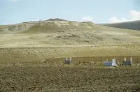
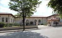
Photo: Ingeborg Simon · CC BY-SA 3.0
Catalogue label
- Type
- Archaeology
- Kind
- Archaeological site
- Province / district
- Sivas
- Elevation
- 1,228 m
- Wikidata
- Q391065
About
Šamuḫa is an ancient Bronze Age settlement near the village of Kayalıpınar, Yıldızeli, c. 40 km west of Sivas, in the Sivas Province of Turkey. It was a city of the Hittites, a religious centre and, for a few years, a military capital for the empire. It is located on the northern bank of the Kizil Irmak river, which was called Marassanta by the Hittites and Halys during the classical era. Samuha's faith was syncretistic. Rene Lebrun in 1976 called Samuha the "religious foyer of the Hittite Empire".
Text: Wikipedia, CC BY-SA 4.0 · Read more on Wikipedia
Location
Visiting here? The next 5 places nearby
The best-known places close by, in the shortest order from Samuha Antik Kenti: about 222 km and 3 h 50 min of travel, plus roughly 6 h 30 min for the visits.
67 km · 1 h 7 min by car
 Kuşaklı
Sivas
70 km · 1 h 10 min by car
0.9 km · 11 min on foot
39 km · 39 min by car
 Bathys Rhyax
Sivas
45 km · 45 min by car
 Berissa
Tokat
Directions for this routeDistances are straight-line estimates adjusted for roads; check each museum's hours before you go.
Wrong information?Tell usFix it on OpenStreetMap