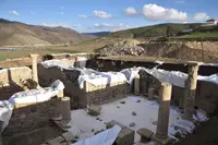
Altıntepe
Erzincan · Archaeological site
Photo: Bertramz · CC BY-SA 3.0
Catalogue label
- Type
- Archaeology
- Kind
- Archaeological site
- Province / district
- Erzincan
- Elevation
- 1,219 m
- Wikidata
- Q447212
About
Altıntepe (Turkish for "golden hill") or Yerez (Armenian: Երեզ) is an Urartian fortress and temple archaeological site dating from the 9th to 7th century BCE. It is located on a small hill overlooking the Euphrates River in the Üzümlü district of Erzincan Province, Turkey.
Text: Wikipedia, CC BY-SA 4.0 · Read more on Wikipedia
Location
Visiting here? The next 3 places nearby
The best-known places close by, in the shortest order from Altıntepe: about 97 km and 1 h 35 min of travel, plus roughly 3 h 30 min for the visits.
21 km · 21 min by car
 Erzincan Museum
Erzincan
44 km · 44 min by car
 Satala
Gümüşhane, Kelkit
32 km · 32 min by car
 Kenan Yavuz Museum of Ethnography
Bayburt, Demirözü
Directions for this routeDistances are straight-line estimates adjusted for roads; check each museum's hours before you go.
Wrong information?Tell usFix it on OpenStreetMap